

GIS is an essential component in many decision and management processes. A well-structured GIS provides invaluable tools to visualize, analyze and query geospatial data and associated information about features and objects in both the natural and built environments. Because a GIS database can contain information on a wide variety of features and terrain, it is commonly built and maintained using information produced by a broad range of input and data sources.
As applications for GIS data expand, so does the demand for new and efficient ways to collect and deliver quality, actionable spatial data from the field. Satisfying the seemingly insatiable demand for data doesn’t always involve traditional GIS field technicians. Certain types of geospatial data can be produced by the general public. And in some cases, data collection doesn’t involve humans at all.
The Triple Play of Data Collection
Today’s widely available options for connectivity and Internet-based communications are enabling new approaches to collecting and using GIS information. We can divide the techniques into three broad classifications: crew sourced, crowd sourced and automated acquisition.
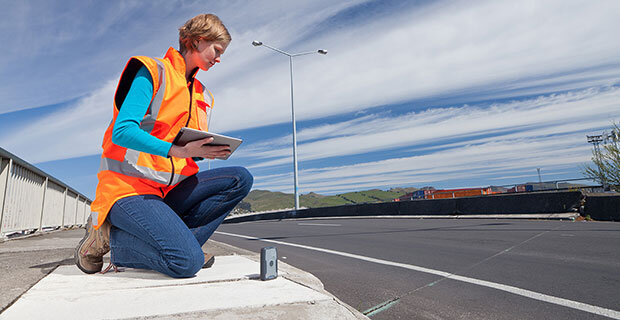
Crew-sourced GIS data follows the traditional path of using personnel who are trained and equipped for GIS data acquisition. Technicians typically possess specialized knowledge in applications for which they are gathering data. For example, a person working to collect wetlands data may be a botanist, environmental scientist or marine biologist. Similarly, people collecting information about roads and highways may have training in civil engineering, transportation technology or related disciplines.
Although field equipment for crew-sourced GIS data collection can include consumer-grade devices such as smart phones or tablets, many organizations prefer to use dedicated equipment. These solutions can operate in difficult environments and provide higher reliability and performance in the commercial and industrial arenas. In addition, solutions such as the Trimble® Geo 7 series handhelds can produce GNSS positions with higher precision than standard smartphones and tablets.
By contrast, crowd-sourced data collection is conducted by the general public and requires little knowledge of assets or technologies. In fact, most people participating in this activity don’t know that they are capturing geospatial data. While the technique can leverage large numbers of potential data collectors, it faces challenges in assessing incoming data to develop reliable, actionable information.
In looking at crowd-sourced data collection, we can identify two common approaches to gathering and using data. Both combine geolocations with user-reported attributes or situations. One method uses apps that enable citizens to report problems or concerns about an item of interest. For example, a person could report a failed traffic signal, broken concrete sidewalk or damage to a road sign. The report, which often includes a GNSS location of the problem, goes to the municipal department responsible for the issue. The department reviews the report and schedules any needed repair or maintenance activities. This “managed crowd-sourced solution” may also include feedback to the citizen upon completion, informing them that their report was heard and acted upon. The feedback helps encourage participation—citizens want to hear that their concerns have been addressed.
A different approach to crowd-sourced GIS data bypasses the review and management of the municipal maintenance system described above. Instead, gathered information is redistributed quickly to other users. One example can be found in applications such as traffic reporting and vehicle routing. Drivers can use smartphone apps to report traffic jams, accidents or construction delays, which can be immediately shared with other drivers using the app. Users can enter information on road closures or changes in road conditions to update the maps used by the system. This near-real-time reporting is an attractive capability and can have an overall benefit on traffic flow, but the approach may lack the quality control and analyses common in crew-sourced or managed crowd-sourced systems.
The third technique, automated data acquisition, is helping GIS to expand into new geographic and applications areas. Fully automated systems can provide continuous positioning and attribute information. For example, geotechnical monitoring solutions use GNSS or optical techniques to capture precise position information. The data can be combined with seismic or structural sensors to model the behavior of the earth or manmade structures such as buildings, bridges, and dams.
Automated sensors can be connected with mobile or portable positioning systems as well. By combining ground-penetrating radar or other sensors with GIS-style positioning equipment, it’s possible to quickly gather data to map underground facilities such as utilities and tunnels. Working in conjunction with the positioning process, the automated sensors help reduce time in the field and reduce or eliminate user error in procedures for data capture and recording.
Other automated sensors can be installed in fixed locations (with locations captured by GNSS sensors) to report data such as traffic, gas and pollutant concentrations, water levels and weather. Municipal utility companies can combine spatial data with the Internet of Things (IoT) to monitor parameters such as water pressure and flow rates. In the case of service outages, automated systems can merge the locations of facilities and sensors together with addresses of customer reports to isolate the causes of trouble.
The Evolving Scene
The different data collection techniques are experiencing varied evolutionary paths. Crew-sourced methods are experiencing increased levels of productivity and efficiency in data acquisition as a result of customized processes and information flow. Crowd-sourced GIS is evolving to reach more people with simple user interaction backed by sophisticated analytics and visualization. Participation by the public is expected to increase as people see faster responses to their comments and input. For automated data collection, rapid growth in the IoT will enable integrated geospatial and enterprise solutions to deliver timely data on natural and manmade features ranging from dams to delivery trucks.
Understanding the advantages and tradeoffs of the three approaches enable geospatial professionals to optimize the cost and results of data acquisition. In doing so, they can deliver the comprehensive, timely information needed in their clients’ decision processes. It’s an important—and valuable—service.


