In the United States, ZIP +4 assists marketers in targeting customers by city, neighborhood, or street, but geospatial location intelligence can help marketers perform much deeper analysis. And “analysis” is where the real value of geospatial lies.
A ZIP + 4 code according to Wikipedia; “uses the basic five-digit code plus four additional digits to identify a geographic segment within the five-digit delivery area, such as a city block, or a group of apartments.” And since the introduction of ZIP + 4 in 1983, this feature has assisted direct marketers (not to mention the USPS) in saving millions of dollars in costs.
While some marketers may decide that ZIP +4 is enough for customer targeting purposes, they’re missing out on a whole level of analysis available from geospatial that can help squeeze more return on investment from scarce marketing dollars.
The term “geospatial” describes a specific type of analytical software combined with geographic data. Going much further than simple ZIP +4 formats, geospatial comes to life via the transformation of a customer address into geographic coordinates (latitude and longitude). With geospatial, a whole host of marketing analytics is …
In the United States, ZIP +4 assists marketers in targeting customers by city, neighborhood, or street, but geospatial location intelligence can help marketers perform much deeper analysis. And “analysis” is where the real value of geospatial lies.
A ZIP + 4 code according to Wikipedia; “uses the basic five-digit code plus four additional digits to identify a geographic segment within the five-digit delivery area, such as a city block, or a group of apartments.” And since the introduction of ZIP + 4 in 1983, this feature has assisted direct marketers (not to mention the USPS) in saving millions of dollars in costs.
While some marketers may decide that ZIP +4 is enough for customer targeting purposes, they’re missing out on a whole level of analysis available from geospatial that can help squeeze more return on investment from scarce marketing dollars.
The term “geospatial” describes a specific type of analytical software combined with geographic data. Going much further than simple ZIP +4 formats, geospatial comes to life via the transformation of a customer address into geographic coordinates (latitude and longitude). With geospatial, a whole host of marketing analytics is now available to marketers. Examples include:
- Map locations. By overlaying geospatial data types with a mapping tool (such as Google Earth) marketers can pinpoint store or office locations in proximity to customers.
- Calculate distances between locations. Stores, offices or distribution centers can be precisely calculated and then evaluated to examine if they are too close or too far apart. For example, marketers can determine the midpoint between two stores to meet the needs of an under-served customer segment. With geospatial, there’s no guessing, whereas it’s pretty difficult to calculate the distance between locations with ZIP +4.
- Marketing by the mile (or less). Suppose you have a specific store location and you want to market to households 5.1 miles to the north, 2.5 miles to the south, etc; essentially building your own polygon for direct marketing purposes. With geospatial capability, you can do this exercise; ZIP +4—not so much.
- Disaster planning. When an event occurs, let’s say a hurricane is brewing, will you be able to see which stores will be in its path? How about households? How might this event affect your ongoing or future marketing campaigns?
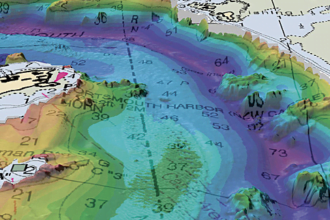
- Risk management. Customer concentration or density analysis (see below) can identify specific areas in which you may be taking on too much risk.
A visual example of density analysis. Source

Some marketers want to know, in comparing ZIP +4 vs. geospatial—which is best? The answer depends on your specific problem, resource constraints, and level of analysis required.
ZIP +4 can help a marketer drill down towards a fairly small area for targeting and the process of converting a mailing list to ZIP +4 is relatively inexpensive. Whereas, adding geo-spatial capabilities usually involves use of an analytical infrastructure (database and hardware), software applications (i.e., data integration and visualization tools), and both technical and business know-how to perform analysis and act upon newly discovered information.
ZIP +4 may work best as an inexpensive way to improve customer targeting. However, as seen from the above marketing examples, geospatial capabilities open a whole host of analytical options for marketers that ZIP +4 just cannot match.
Questions:
- With three billion mobile phone users in the world (and growing) will “location” become an increasingly important component of marketing in the next 3-5 years?
- A business intelligence infrastructure is a necessary pre-cursor to geospatial analysis. What does this say about the skills set marketers will need in the future to perform such analysis?